
About
Death Valley National Park is located in eastern California and extends into southern Nevada. Established as a national monument in 1933 and redesignated as a national park in 1994, it covers approximately 5,270 square miles (13,650 sq km), making it the largest national park in the contiguous United States.
The park protects a vast and dramatic desert landscape of salt flats, sand dunes, canyons, mountains, badlands, and volcanic features. Known for its extremes, Death Valley is one of the hottest, driest, and lowest places on Earth, yet it supports an astonishing diversity of life adapted to its harsh environment.
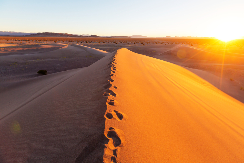
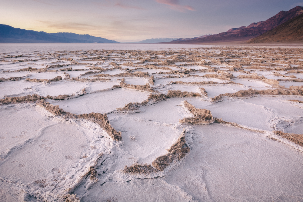
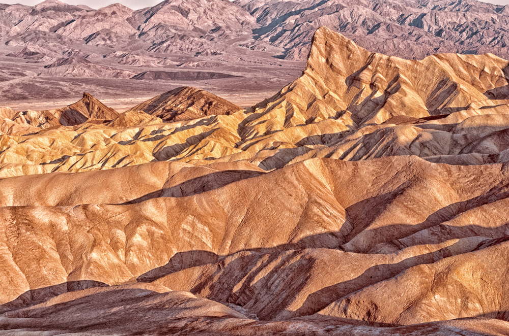
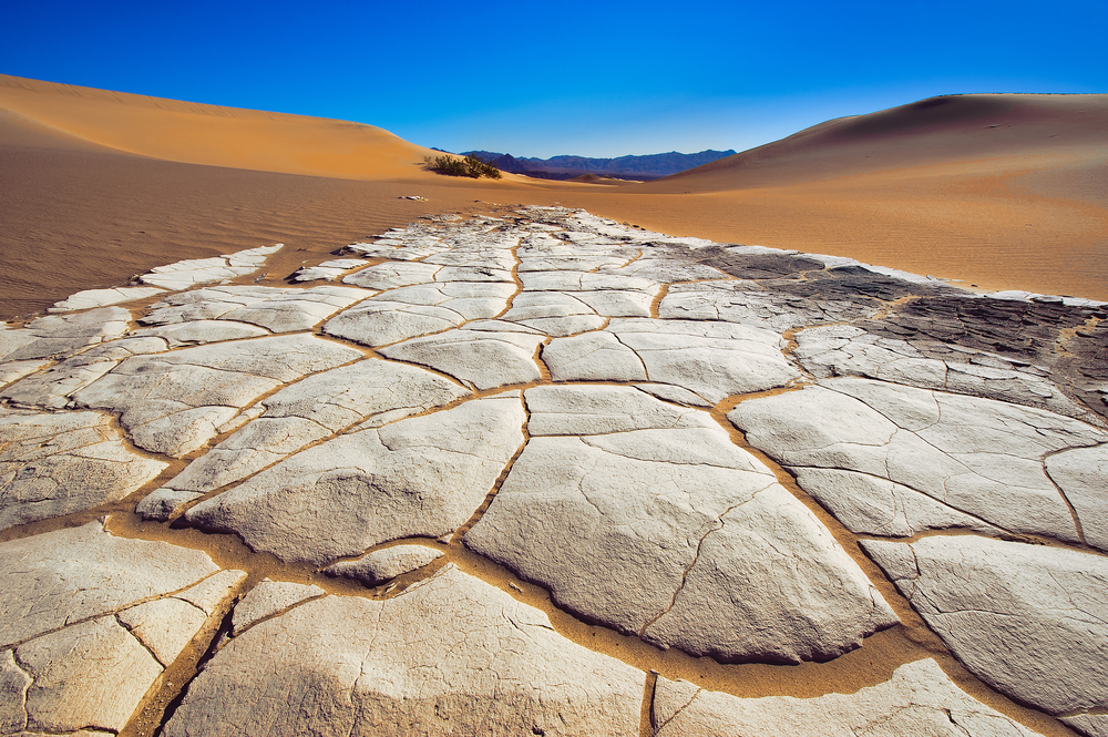
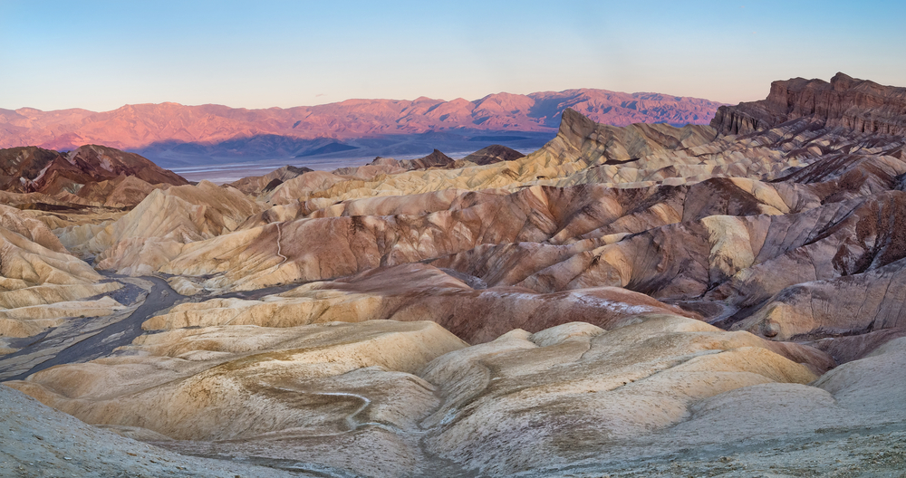
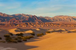
The park is best known for its record-breaking temperatures and otherworldly desert scenery. Visitors are drawn to iconic destinations such as Badwater Basin, the lowest point in North America at 282 feet (86 m) below sea level. Other famous attractions include Zabriskie Point, known for its colorful badlands; Mesquite Flat Sand Dunes; and Artist’s Drive, where mineral-rich hills display vibrant colors.
Hiking, scenic driving, photography, stargazing, and backcountry exploration are among the park’s most popular activities. Its vast open spaces and dramatic landscapes make it one of the most visually distinctive national parks in the world.
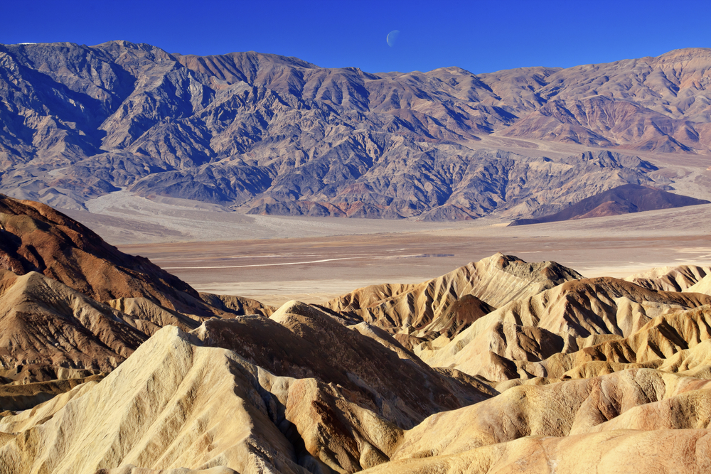
Geographically, Death Valley National Park lies within the Basin and Range Province, a region characterized by alternating mountain ranges and desert valleys. The park contains dramatic elevation changes, from the depths of Badwater Basin to the summit of Telescope Peak, which rises to 11,049 feet (3,368 m). This elevation range creates an extraordinary diversity of climates and ecosystems. T
he landscape includes salt flats, alluvial fans, sand dunes, volcanic craters, rugged canyons, and ancient lakebeds. Despite receiving less than two inches (5 cm) of annual rainfall in some areas, seasonal storms occasionally transform the desert with spectacular wildflower blooms.
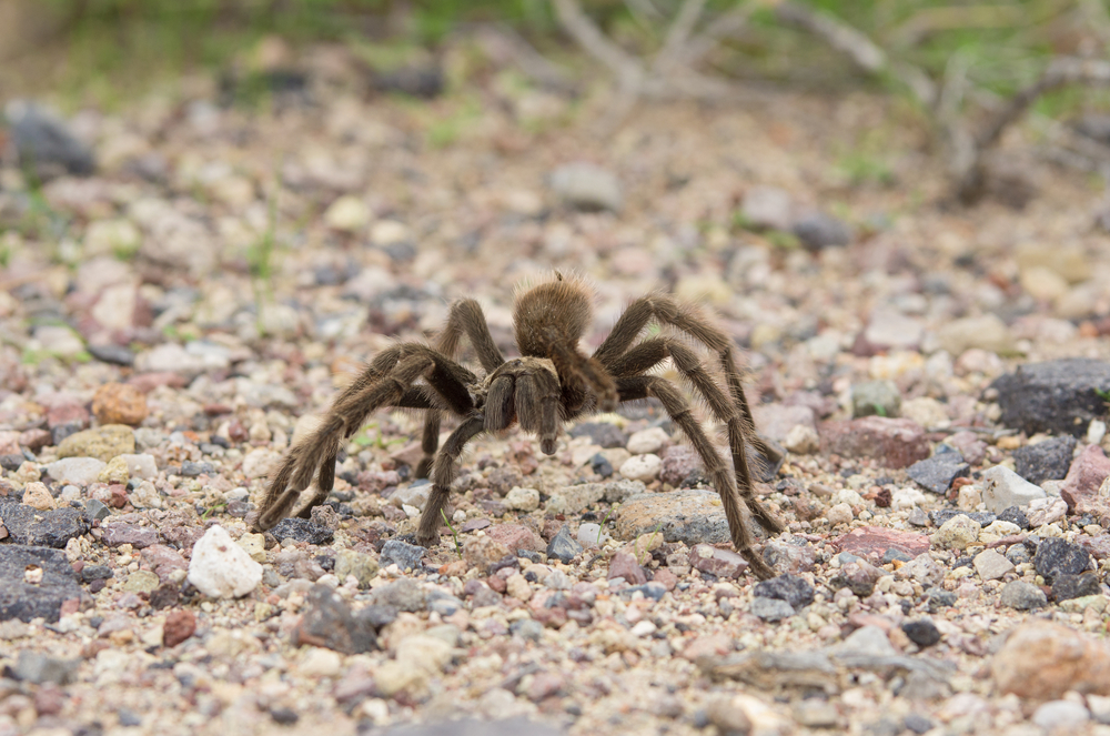
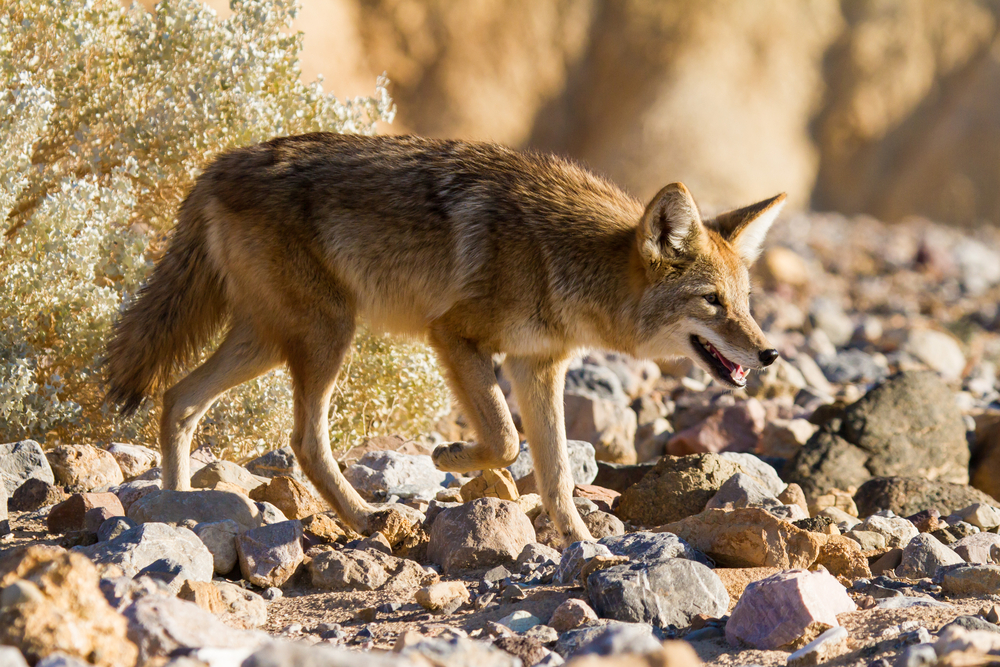
Wildlife within Death Valley National Park demonstrates remarkable adaptation to extreme conditions. Mammals include desert bighorn sheep, coyotes, kit foxes, bobcats, jackrabbits, kangaroo rats, and several bat species. Birdlife includes roadrunners, golden eagles, ravens, phainopeplas, and migratory species that utilize desert oases and mountain habitats.
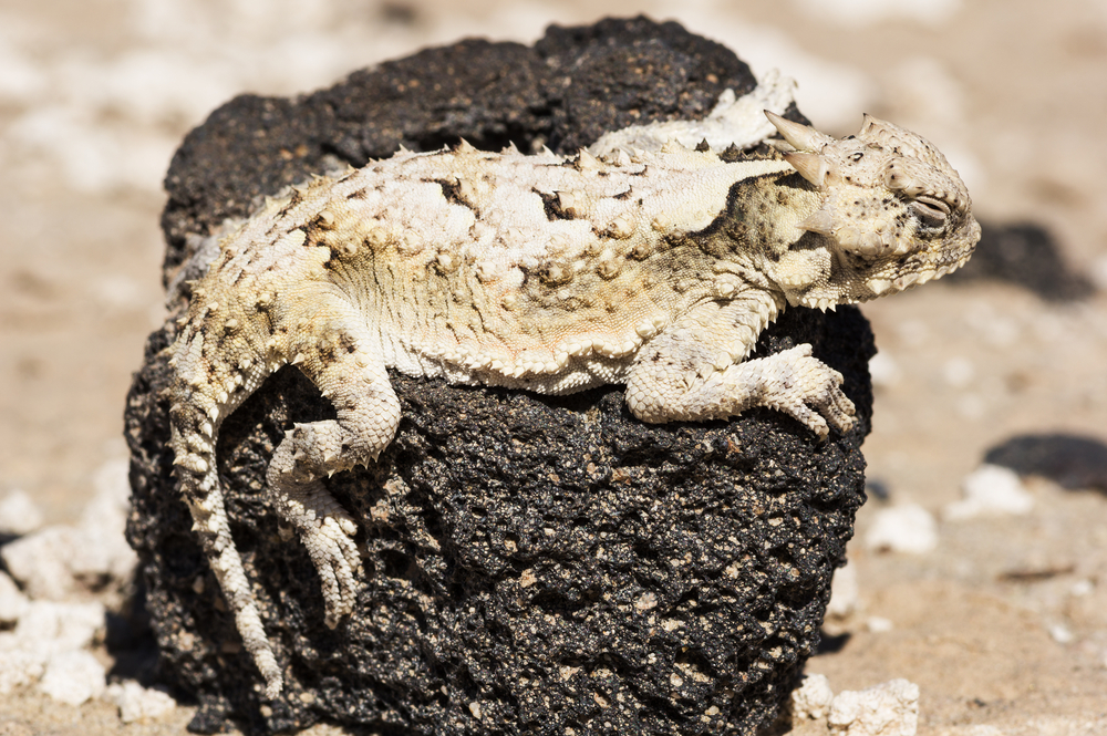
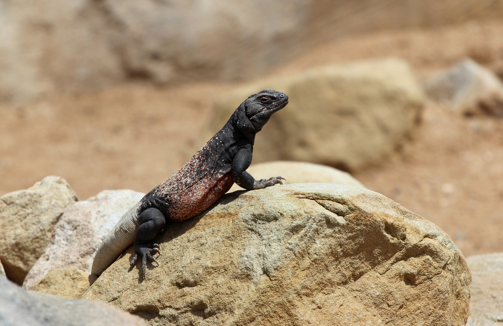
Reptiles are particularly abundant, with sidewinder rattlesnakes, desert tortoises, chuckwallas, and horned lizards thriving in the arid environment. The park also supports unique aquatic species, including the endangered Devils Hole Pupfish, one of the rarest fish in the world, found in a nearby desert spring ecosystem.
Death Valley National Park plays a critical role in preserving one of North America’s most extreme and fascinating desert ecosystems. The park protects vast wilderness areas, unique geological formations, rare species, and important scientific resources that help researchers understand desert ecology and climate change.
Its conservation significance is often compared to Joshua Tree National Park and Wadi Rum Protected Area because of its dramatic desert landscapes, biodiversity, and geological wonders. Through its towering mountains, salt flats, colorful canyons, rare wildlife, and unparalleled desert scenery, Death Valley National Park stands as one of America’s most extraordinary protected areas and a showcase of nature’s ability to thrive under extreme conditions.
Photos


Things to See
 Mojave Desert
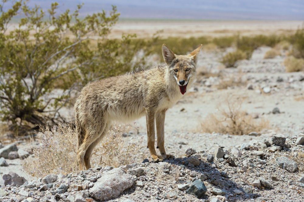
Things To Do
Engaging Death Valley

Death Valley National Park Trails
Death Valley is arid making the need for managed or constructed trails irrelevant. The majority of hikes travel across the desert floor, through canyons, or along the ridges of the mountains.

Park Protection
 Death Valley National Park was created to protect an immense desert landscape of extreme environments, unique geology, and specialized wildlife adapted to some of the harshest conditions on Earth. The park provides habitat for several rare and endemic species, including the endangered Devils Hole pupfish, one of the world’s rarest fish and found naturally in only a single desert spring system. Other protected species include desert bighorn sheep and numerous plants uniquely adapted to the arid Mojave Desert.
The park contains the lowest elevation in North America at Badwater Basin and protects vast salt flats, sand dunes, canyons, volcanic features, and mountain ranges. Its remarkable diversity of habitats supports life across dramatic elevation changes despite its reputation as an extreme desert. Together, Death Valley National Park safeguards rare desert ecosystems, endemic species, extraordinary geological features, and one of the most unique landscapes found anywhere in the world.
FAQ’s
What is the hottest location in the United States?
The hottest location in the United States is indeed Death Valley, particularly the Furnace Creek area. Death Valley holds the record for the highest reliably reported air temperature on Earth, which reached 134°F (56.7°C) on July 10, 1913, at Furnace Creek Ranch.
The valley’s extreme heat is attributed to its low elevation, below sea level, coupled with its arid climate and lack of vegetation.
While other locations may occasionally experience higher temperatures during heatwaves, Death Valley consistently ranks among the hottest places on Earth.
Its extreme temperatures and harsh environment make it a unique and challenging destination for visitors seeking to experience one of nature’s most extreme environments.
What is the main reason people visit Death Valley National Park?
Death Valley National Park is primarily visited for its extraordinary desert landscapes, extreme geology, and unique natural phenomena. Located in eastern California and western Nevada, it is the largest national park in the contiguous United States.
Visitors come to experience vast salt flats, colorful badlands, towering sand dunes, rugged mountains, scenic drives, stargazing, wildflower blooms, and some of the most dramatic desert scenery on Earth.
What animals can visitors hope to see in Death Valley National Park?
Death Valley National Park supports approximately 50 mammal species and more than 35 reptile species. Despite its reputation as one of the hottest and driest places on Earth, the park contains a surprising diversity of wildlife adapted to desert conditions.
Some of the most notable mammals found in Death Valley National Park include:
- Desert Bighorn Sheep
- Mule Deer
- Mountain Lion
- Bobcat
- Coyote
- Gray Fox
- Kit Fox
- Red Fox (higher elevations)
- American Badger
- Ringtail
- Raccoon
- Long-tailed Weasel
- Striped Skunk
- Black-tailed Jackrabbit
- Desert Cottontail
- Antelope Ground Squirrel
- Rock Squirrel
- Golden-mantled Ground Squirrel
- Cliff Chipmunk
- Kangaroo Rat
- Pocket Mouse
- Deer Mouse
- Canyon Mouse
- Woodrat
- Pocket Gopher
- Porcupine
- Beaver
- Muskrat
- Desert Shrew
- Pallid Bat
- Big Brown Bat
- Hoary Bat
- Mexican Free-tailed Bat
- Townsend’s Big-eared Bat
- Western Pipistrelle
- California Myotis
- Yuma Myotis
- Long-legged Myotis
- Fringed Myotis
- Silver-haired Bat
- Desert Rodent Species
- Harvest Mouse Species
- Pack Rat Species
- Ground Squirrel Species
- Vole Species
- Small Carnivore Species
- Bat Colony Species
- Various Rodent Species
- Various Small Mammals
- Various Desert Mammals
What birds can visitors hope to see in Death Valley National Park?
Death Valley National Park is home to more than 350 bird species. The park’s desert basins, mountains, springs, and oases provide habitat for a remarkable variety of resident and migratory birds.
Some of the most popular birds seen in Death Valley National Park include:
- Golden Eagle
- Bald Eagle
- Prairie Falcon
- Peregrine Falcon
- Red-tailed Hawk
- Cooper’s Hawk
- Sharp-shinned Hawk
- Northern Harrier
- American Kestrel
- Turkey Vulture
- Greater Roadrunner
- Gambel’s Quail
- Mountain Quail
- Common Raven
- Pinyon Jay
- Clark’s Nutcracker
- Woodhouse’s Scrub-Jay
- Black-billed Magpie
- Mountain Bluebird
- Western Bluebird
- Canyon Wren
- Rock Wren
- Bewick’s Wren
- Cactus Wren
- Black-throated Sparrow
- Brewer’s Sparrow
- Chipping Sparrow
- White-crowned Sparrow
- Sagebrush Sparrow
- Horned Lark
- Western Meadowlark
- Say’s Phoebe
- Ash-throated Flycatcher
- Western Kingbird
- Vermilion Flycatcher
- Violet-green Swallow
- Cliff Swallow
- Barn Swallow
- White-throated Swift
- Black-chinned Hummingbird
- Costa’s Hummingbird
- Rufous Hummingbird
- Ladder-backed Woodpecker
- Northern Flicker
- Juniper Titmouse
- Bushtit
- Yellow-rumped Warbler
- Orange-crowned Warbler
- Western Tanager
- Pyrrhuloxia
Is Death Valley National Park worth visiting?
Yes, Death Valley National Park is absolutely worth visiting and is considered one of the most unique national parks in the world.
The park offers spectacular scenery, extreme landscapes, colorful geological formations, vast salt flats, dramatic mountain ranges, sand dunes, and exceptional stargazing. Visitors can experience environments ranging from below sea level deserts to snow-covered mountain peaks. Its sheer scale and diversity make it one of the most fascinating destinations in North America.
What is the best time to visit Death Valley National Park?
The best time to visit Death Valley National Park is:
- November through March
During these months:
- Temperatures are comfortable.
- Hiking conditions are favorable.
- Scenic drives are enjoyable.
- Wildlife is more active.
Spring can bring spectacular wildflower displays during favorable rainfall years. Summer temperatures frequently exceed 120°F (49°C), making outdoor activities dangerous.
How many days do you need to visit Death Valley National Park?
Most visitors should plan for 2 to 4 days.
- 1 day: Major viewpoints and scenic attractions.
- 2 days: Salt flats, canyons, and sand dunes.
- 3–4 days: Extensive exploration of multiple regions.
- 5+ days: Backcountry roads, hiking, photography, and remote wilderness experiences.
The park’s immense size rewards longer visits.
How do you get to Death Valley National Park?
Death Valley National Park is located in eastern California near the Nevada border.
Most visitors:
- Fly into Las Vegas, Los Angeles, or Reno.
- Drive to the park via state and federal highways.
- Access the park through several entrances depending on travel direction.
Las Vegas is the most common gateway city and is approximately two hours from the park.
Is Death Valley National Park safe for tourists?
Yes, Death Valley National Park is generally safe for visitors when proper precautions are taken.
Visitors should:
- Carry large amounts of water.
- Avoid strenuous activity during extreme heat.
- Keep vehicles fueled and maintained.
- Inform others of travel plans.
- Stay on established roads.
- Monitor weather and flash-flood forecasts.
Most safety concerns involve heat-related illness, dehydration, and the park’s remote nature.
Who is involved in protecting and supporting Death Valley National Park?
Several organizations help protect Death Valley National Park:
- National Park Service – manages Death Valley National Park.
- Death Valley Natural History Association – supports education, interpretation, and conservation programs.
- National Park Foundation – supports projects throughout the National Park System.
- Friends of Nevada Wilderness – supports conservation efforts in the broader region.
- Scientists, volunteers, and conservation organizations that help protect the park’s ecosystems and cultural resources.
Sources
- American Southwest, Badwater, Death Valley National Park, https://www.americansouthwest.net/california/death_valley/badwater.html, retrieved June 2020.
- Britannica, Death Valley, https://www.britannica.com/place/Death-Valley, retrieved June 2020.
- Britannica, Glacier Bay National Park, https://www.britannica.com/place/Death-Valley-National-Park, retrieved June 2020.
- California, Death Valley National Park, https://www.visitcalifornia.com/destination/spotlight-death-valley-national-park, retrieved June 2020.
- National Geographic, Death Valley National Park, https://www.nationalgeographic.com/travel/national-parks/death-valley-national-park/, retrieved June 2020.
- National Geographic, Complete National Parks of the United States, National Geographic Publishing, Washington DC.
- National Geographic, Guide to the National Parks of the United States, National Geographic Society, 2003.
- National Geographic, National Parks of North America, Canada-United States-Mexico, National Geographic Society, 1995.
- National Park Service, Death Valley, https://www.nps.gov/deva/index.htm, retrieved June 2020.
- UNESCO, Mojave and Colorado Deserts, http://www.unesco.org/mabdb/br/brdir/directory/biores.asp?mode=all&Code=USA+39, retrieved June 2020.
- Wikipedia, Mojave Desert, https://en.wikipedia.org/wiki/Mojave_Desert, retrieved June 2020.