About

Vikos Aoos National Park is located in the northwestern corner of Greece.  The park covers an area of 49 square miles (126.91 sq km).

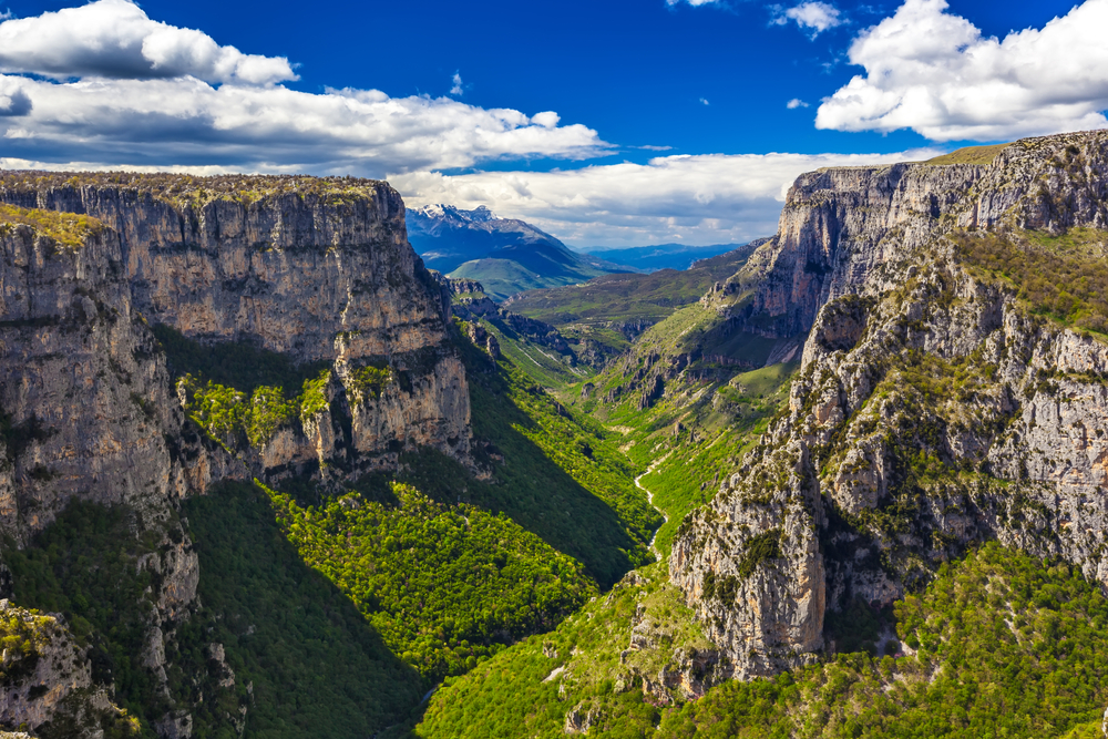
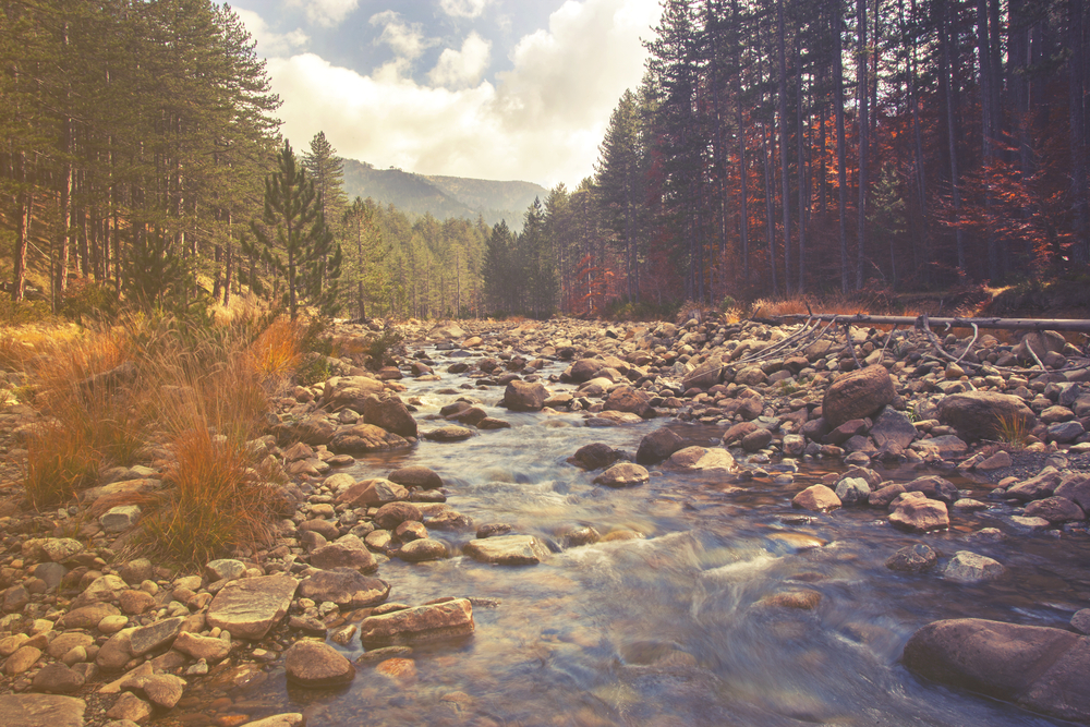
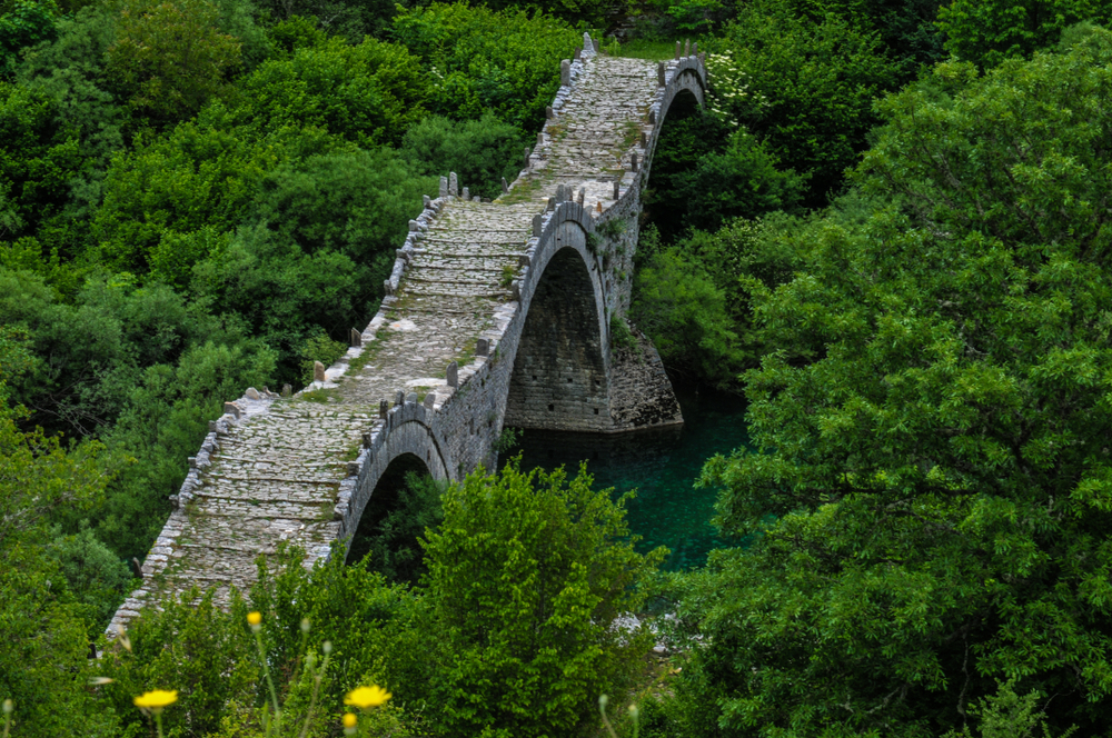
The park is named after the two gorges found within the borders of the park.  The gorges are named Vikos Gorge and Aoos Gorge.  Along with the two gorges the park is comprised of mountains, rivers, lakes, caves, and deep canyons.

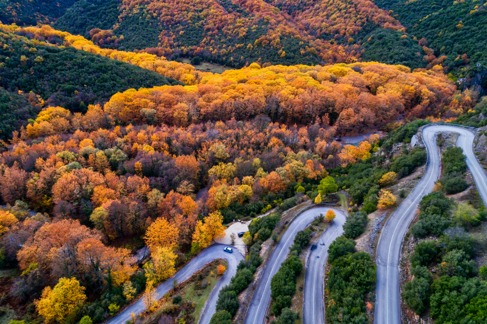
Many of these landscapes are blanketed with thick coniferous and deciduous woodlands.  The elevations of the park vary from 1,804 to 8,192 feet (550 to 2,497 m). The highest point occurs at Mount Tymfi.

These varying elevations and vegetation areas have established three habitat regions that support the diverse wildlife of the area.  Part of the vegetation zones include grasslands, shrublands, and varied woodlands further supporting the animal species of the park.

Some of the more popular species include roe deer, brown bear, chamois, fox, wolf, otter, lynx, and wild cat.  There are over 120 species of birds with at least 15 raptor species highlighting the potential sightings.

Things to See

The natural facets of the park create a tremendous place for hiking, kayaking, mountain biking, and rafting.  Many people say the highlight is engaging this astounding landscape through one of these activities.  The two gorges are often considered the pinnacle attractions.

Vikos Gorge

Vikos Gorge is located along the southern slopes of Mount Tymfi of the Pindus Mountains.  The gorge covers a distance of 12.43 miles (20 km) while reaching a maximum width of 1,312.3 feet (400 m).

The depth of the gorge varies from 393.70 to 1,607.6 feet (120 to 490 m).  The Guinness Book of Records declares Vikos as the deepest gorge in the world relative to its width.

There is a viewing platform at Oxia which allows visitors to look out over the deepest part of the gorge. 

Aoos Gorge

The Aoos Gorge extends a distance of 6 miles (10 km).  The gorge is carved by the Aoos River and travels between Mount Tymphe, Mount Trapezitsa, and Mount Raidovouni.  The natural landscape is adorned with monasteries as well as single-arched bridges that were constructed during the 17th through the 19th century. 

Visitors get a taste of history and culture while exploring the gorge.

Mount Tymfi

Mount Tymfi is also known as Tymphe, Timfi, and Tymphi. This massif features its highest point at Gamila.  The peak is 8,192 feet (2,497 m) high.  The mountain features a long plateau that some say resembles Table Mountain in South Africa.

Vikos-Aoos National Park Trails

Hiking around the exquisite landscapes sits atop the interest of the majority of travelers who visit the national park.  There are several trails ranging from easy to difficult and short to longer adventures.

placeholder

Ice Age Voidomatis Trail

This is rated easy with an elevation gain of only 521 feet (158.8 m) while traveling 5.9 miles (9.49 km) before returning.  The trail meanders through the forest and along a river providing great woodland landscapes.

placeholder

Oxya Viewpoint Trail

This is a short 0.4-mile (0.64 km) trail that travels through the forest out to an incredible panoramic view of the cliffs and valley below.  It is rated easy and the view is astounding.

placeholder

Vikos Gorge Trail

This trail covers a distance of 7.3 miles (11.7 km) while ascending 2,024 feet (616.92 m) before returning back down.  The trail travels through the famous gorge and accompanying forest.  There is a chance to see wildlife while witnessing the different highlights of the gorge.

placeholder

Vradeto Steps Trail

This is an out and back trail that descends 1,046 feet (318.8 m) over 3.1 miles (4.99 km) to the bottom of the gorge. While views of the gorge are highlights there are also chances to see wildlife while trekking through the forest.

placeholder

Vikos Gorge North to South Trail

This is a second opportunity to hike the renowned gorge.  This trail is rated difficult while ascending 3,182 feet (969.87 m) over a distance of 7.1 miles (11.4 km). Camping and backpacking are popular activities of this trail which also gives you a chance to see wildlife while exploring the gorge.  The views are astounding.

placeholder

Vikos Gorge Trail

Rating: Moderate to Difficult

Distance and Elevation Gain: 12 miles (20 km) one way, 2,600 feet (800 meters)

Description: This iconic trail traverses the Vikos Gorge, one of the deepest in the world.

Hikers start from Monodendri and finish in Vikos, moving through diverse ecosystems, alongside streams, and under towering cliffs.

The path offers breathtaking views of the gorge’s limestone walls and a chance to discover rare herbs and wildflowers.

placeholder

Aoos Springs Trail

Rating: Moderate

Distance and Elevation Gain: 5 miles (8 km) round trip, 1,300 feet (400 meters)

Description: Beginning near Konitsa, this trail follows the Aoos River to its springs.

Hikers can enjoy lush landscapes, crystal-clear waters, and the serene atmosphere of the river valley.

It’s an excellent route for spotting local wildlife and enjoying the tranquility of the park’s northern reaches.

placeholder

Monodendri to Oxia Viewpoint

Rating: Easy

Distance and Elevation Gain: 1 mile (1.6 km) round trip, minimal elevation gain

Description: A short and accessible trail that leads from the village of Monodendri to the Oxia viewpoint, offering stunning panoramic views of the Vikos Gorge.

The path is well-maintained, making it suitable for families and visitors of all ages looking for a quick but memorable experience of the park’s natural beauty.

placeholder

Dragon Lake (Drakolimni) of Tymfi

Rating: Difficult

Distance and Elevation Gain: 10 miles (16 km) round trip, 3,280 feet (1,000 meters)

Description: This challenging hike takes adventurers to the alpine Dragon Lake, nestled atop the Tymfi mountain range.

The trail, starting from Mikro Papingo, climbs through forests and alpine meadows, offering spectacular views before reaching the mythical lake.

It’s a haven for endemic species and offers unmatched vistas of the Pindus Mountains.

placeholder

Vradeto Stairs and Beloi Viewpoint

Rating: Moderate

Distance and Elevation Gain: 4 miles (6.4 km) round trip, 800 feet (244 meters)

Description: This historic trail connects the villages of Vradeto and Kapesovo via the Vradeto Stairs, a stone path built in the 16th century.

The hike includes a detour to the Beloi Viewpoint, which offers one of the most impressive vistas of the Vikos Gorge.

This path provides a unique blend of cultural history and natural beauty.

placeholder

Vikos Gorge Trail

Rating: Moderate to Difficult

Distance and Elevation Gain: 12 miles (20 km) one way, 2,600 feet (800 meters)

Description: This iconic trail traverses the Vikos Gorge, one of the deepest in the world.

Hikers start from Monodendri and finish in Vikos, moving through diverse ecosystems, alongside streams, and under towering cliffs.

The path offers breathtaking views of the gorge’s limestone walls and a chance to discover rare herbs and wildflowers.

placeholder

Aoos Springs Trail

Rating: Moderate

Distance and Elevation Gain: 5 miles (8 km) round trip, 1,300 feet (400 meters)

Description: Beginning near Konitsa, this trail follows the Aoos River to its springs.

Hikers can enjoy lush landscapes, crystal-clear waters, and the serene atmosphere of the river valley.

It’s an excellent route for spotting local wildlife and enjoying the tranquility of the park’s northern reaches.

placeholder

Monodendri to Oxia Viewpoint

Rating: Easy

Distance and Elevation Gain: 1 mile (1.6 km) round trip, minimal elevation gain

Description: A short and accessible trail that leads from the village of Monodendri to the Oxia viewpoint, offering stunning panoramic views of the Vikos Gorge.

The path is well-maintained, making it suitable for families and visitors of all ages looking for a quick but memorable experience of the park’s natural beauty.

placeholder

Dragon Lake (Drakolimni) of Tymfi

Rating: Difficult

Distance and Elevation Gain: 10 miles (16 km) round trip, 3,280 feet (1,000 meters)

Description: This challenging hike takes adventurers to the alpine Dragon Lake, nestled atop the Tymfi mountain range.

The trail, starting from Mikro Papingo, climbs through forests and alpine meadows, offering spectacular views before reaching the mythical lake.

It’s a haven for endemic species and offers unmatched vistas of the Pindus Mountains.

placeholder

Vradeto Stairs and Beloi Viewpoint

Rating: Moderate

Distance and Elevation Gain: 4 miles (6.4 km) round trip, 800 feet (244 meters)

Description: This historic trail connects the villages of Vradeto and Kapesovo via the Vradeto Stairs, a stone path built in the 16th century.

The hike includes a detour to the Beloi Viewpoint, which offers one of the most impressive vistas of the Vikos Gorge.

This path provides a unique blend of cultural history and natural beauty.

Park Protection

The national park was created to protect the terrain and landscape that surrounds these two stunning gorges.  The park protects one of the most diverse woodland ecosystems in Greece with wildlife treasures like wolves, foxes, wild horses, and roe deer.

Sources